作者zonslan (困難不應退)
看板TY_Research
標題[翻譯] 極端的AO負相位讓北極溫暖
時間Wed Jan 6 12:38:12 2010
簡單翻譯一下下面這則NSIDC(national snow and ice data center)上的新聞
翻譯的不好還請見諒@@(重點翻譯)
http://nsidc.org/arcticseaicenews/index.html (原文出處)
Extreme negative phase of the Arctic Oscillation yields a warm Arctic
極端的北極震盪負相位使北極溫暖
Arctic sea ice extent at end of December 2009 remained below normal,
primarily in the Atlantic sector of the Arctic. Average air temperatures over
the Arctic Ocean were much higher than normal for the month, reflecting
unusual atmospheric conditions. Finally, we provide a review of 2009 Arctic
sea ice conditions.
2009年12月底,北極海冰的面積仍小於正常值,主要是在大西洋區塊這。這個月北冰洋的平
均氣溫明顯高於正常值,反應了不正常的大氣環流....
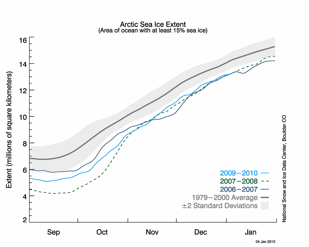
During December 2009, ice extent grew at an average of 68,000 square
kilometers (26,000 square miles) per day. Sea ice extent increased at a
fairly steady rate throughout the month, staying slightly above the levels
observed in December 2007.
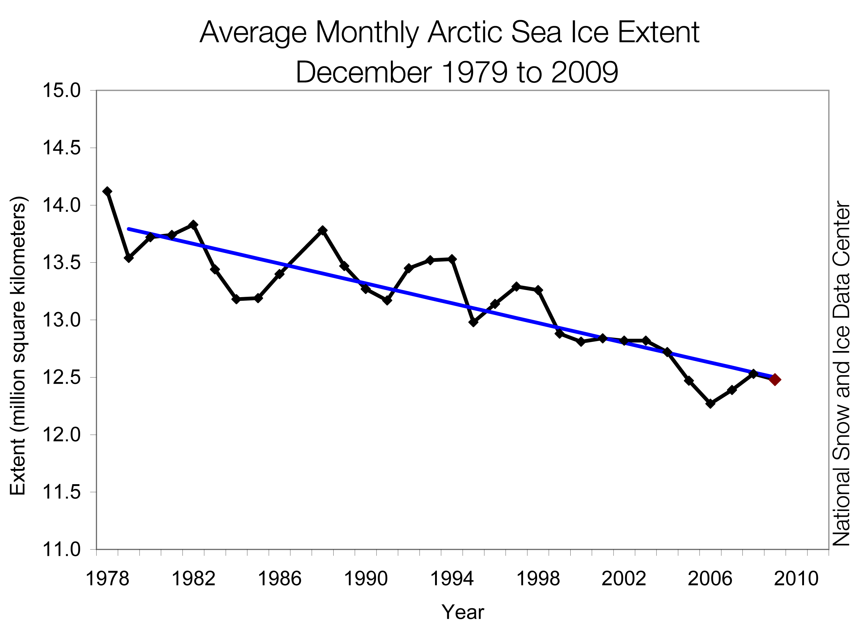
December 2009 had the fourth-lowest average ice extent for the month since
the beginning of satellite records, falling just above the extent for 2007.
The linear rate of decline for December is now 3.3% per decade.
北極海冰面積在2009年12月是有衛星紀錄以來,12月的第四小面積,只比2007年高出一些,
http://nsidc.org/images/arcticseaicenews/20100105_Figure2.png
http://nsidc.org/images/arcticseaicenews/20100105_Figure3.png
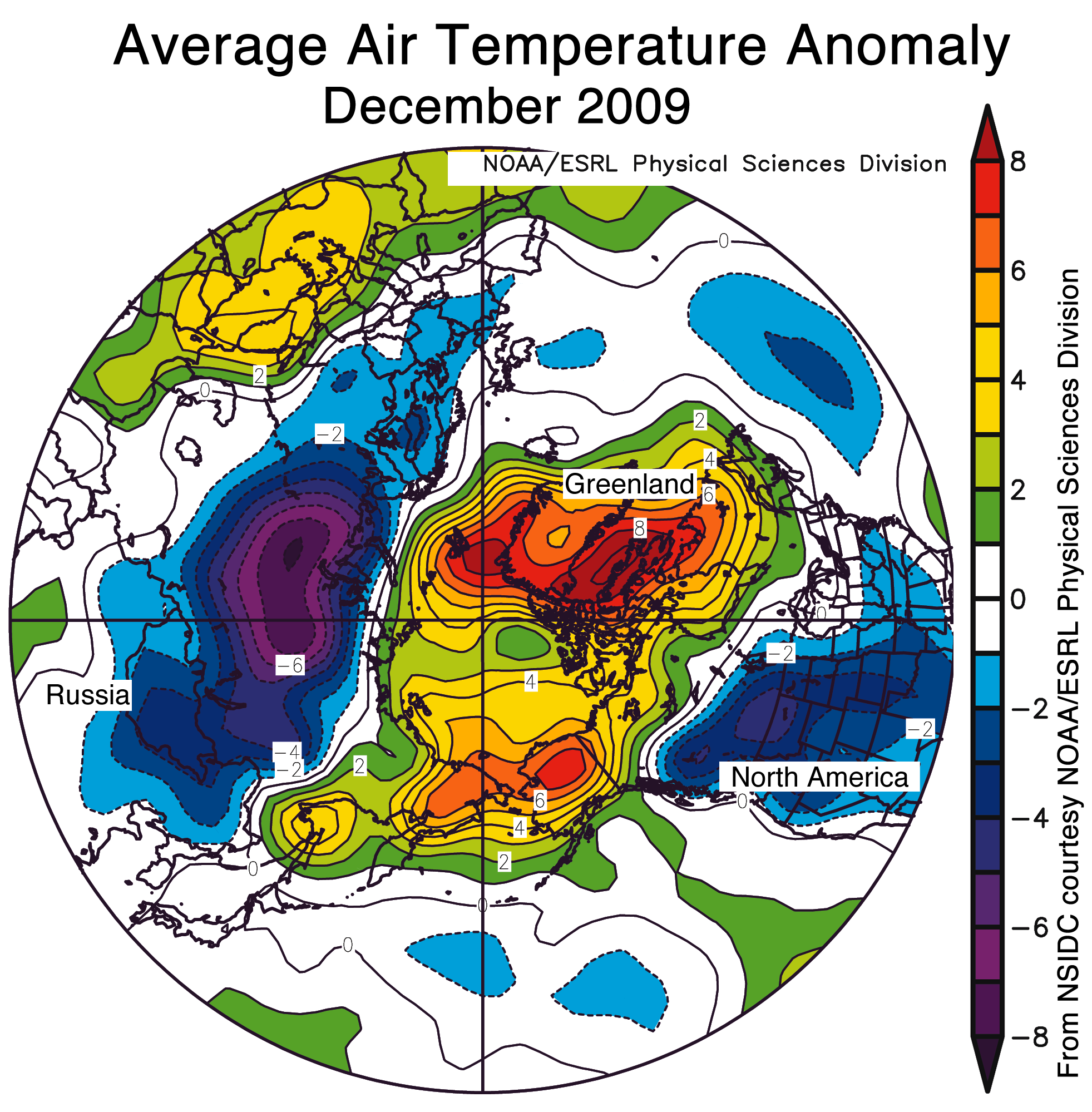
December air temperatures over the Arctic Ocean region, eastern Siberia, and
northwestern North America were warmer than normal. In contrast, temperatures
in Eurasia, the United States, and southwestern Canada were below average.
The strongest anomalies (more than 7 degrees Celsius/13 degrees Fahrenheit)
were over the Atlantic side of the Arctic, including Baffin Bay and Davis
Strait, where ice extent was below average.
北冰洋,東西伯利亞,西北美在12月份的氣溫高於平均,而歐亞大陸,美國,西南加拿大則低於
平均。最強的正距平(超過攝氏7度以上)出現在北冰洋的大西洋區,包含巴芬灣,戴維斯海峽
(都在加拿大和格陵蘭間),這些地方剛好也是海冰面積低於平均的地方。
http://nsidc.org/images/arcticseaicenews/20100105_Figure4.png
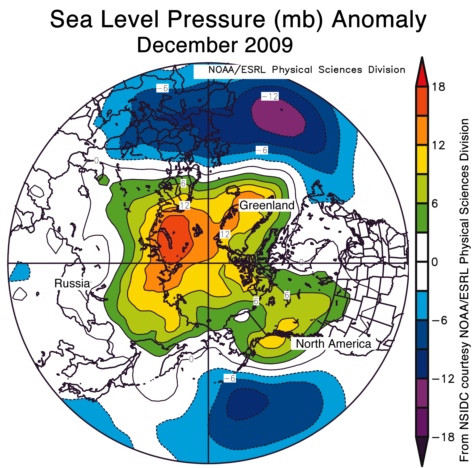
These regional contrasts in temperature anomalies resulted from a strongly
negative phase of the Arctic Oscillation (AO). The AO is a natural pattern of
climate variability. It consists of opposing patterns of atmospheric pressure
between the polar regions and middle latitudes. The positive phase of the AO
exists when pressures are lower than normal over the Arctic, and higher than
normal in middle latitude. In the negative phase, the opposite is true;
pressures are higher than normal over the Arctic and lower than normal in
middle latitudes. The negative and positive phases of the AO set up opposing
temperature patterns. With the AO in its negative phase this season, the
Arctic is warmer than average, while parts of the middle latitudes are colder
than normal. The phase of the AO also affects patterns of precipitation,
especially over Europe.
這現象源自於強勁的負相位北極震盪。北極震盪是一種自然的氣候變化。它由相反的極區
和中緯度氣壓形式所組成。當極區氣壓低於正常值,中緯度氣壓高於正常值,這時是正相
位。而當極區氣壓高於正常值,中緯度器壓低於正常值,就是負相位。正負相位的北極震
盪會造成相反的氣溫形式。像是現在的負相位,會讓極區比平常溫暖,但中緯度則會比較
冷。這相位的變化也會影響到降水,尤其是歐洲。
http://nsidc.org/images/arcticseaicenews/20100105_Figure5.png
(12月的氣壓距平圖)
The phase of the AO is described in terms of an index value. In December 2009
the AO index value was -3.41, the most negative value since at least 1950,
according to data from the NOAA Climate Prediction Center.
2009年12月的北極震盪值達到-3.41,這是自1950年來最負的值
While a negative AO leads to warmer temperatures over the Arctic, it also
tends to reduce the flow of sea ice out of the Arctic by affecting the winds
that can export the ice to warmer waters, where it melts. In this way, a
negative AO could help retain some the second- and third-year ice through the
winter, and potentially rebuild some of the older, multiyear ice that has
been lost over the past few years. However, we do not yet know if the
strongly negative AO will persist through the winter, or what its net effect
will be.
當負相位的北極震盪造成極區變的比較溫暖,也會讓海冰流出的情形降低,有助於維持在
兩到三年年齡的海冰,而在過去幾年流失的更老的海冰,也可望再生。不過我們還不知道
這強勁的北極負震盪會不會在這個冬季持續或者是它的影響會是如何。
關於更多北極震盪的資訊,可參閱下面網頁
http://nsidc.org/arcticmet/patterns/arctic_oscillation.html
2009 year in review
The minimum ice extent in September 2009 was greater than the past two
Septembers, but again fell below the long-term average. The melt season began
with a young, thin Arctic sea ice cover, suggesting that significant amounts
of ice would be lost during the melt season. However, a cooler summer with
favorable winds helped preserve the ice.
2009/9的最小海冰面積比過去兩個年份要大,但仍然低於長期平均(第三低),融化季節在
年輕而薄的冰層覆蓋下展開,顯示會有很大量的冰在融化季節流失。但在有利的風向,較
冷的夏季幫忙了海冰的維持。
Despite the cool summer, the ice remained thin and vulnerable at the sea ice
minimum, with little of the older, thicker ice that used to characterize much
of the Arctic. Recently published research by Barber and colleagues shows
that the ice cover was even more fragile at the end of the melt season than
satellite data indicated, with regions of the Beaufort and Chukchi Seas
covered by small, rotten ice floes.
In the fall, the sea ice froze up in fits and starts. The Northern Sea Route
opened in October, even after sea ice extent for the Arctic as a whole had
begun to increase. The annual average extent for 2009 was 11.18 million
square kilometers (4.32 million square miles), 970,000 square kilometers
(375,000 square miles) or 8.0% below 1979 to 2000 average and 740,000 square
kilometers (286,000 square miles) or 6.2% below the 1979 to 2008 average.
--
※ 發信站: 批踢踢實業坊(ptt.cc)
◆ From: 140.109.103.226
推 cgunavy :-AO比正常值暖,為什麼又有助冰層恢復?前面網頁看起 01/06 15:48
→ cgunavy :來也是北極海變冷阿... 01/06 15:49
推 utaceric :感謝翻譯~ 01/06 18:02
→ catmeowmeow :我看完了卻更疑惑@@... 01/07 15:21
→ seeback :大家要不要一起討論討論?我的猜想是西風不強的關係 01/07 17:24
推 seeback :我看前幾天的彭啟明博士給的等溫線圖,除了少數地方 01/07 23:20
→ seeback :溫度高於零度以外,北緯30度以北地區幾乎在零度以下 01/07 23:22
→ seeback :強烈阻塞高壓也是會造成這種現象,然而全球都一致的 01/07 23:23
→ seeback :低溫真的蠻少見的 01/07 23:23
推 SWW :這樣真的有點像明天過後..... 01/08 00:05